Categories
Arts Arts and Culture Exhibit

You are here: Tania Lara’s “Autogéographies”

Lara’s solo exhibition is open at La Centrale galerie Powerhouse.

Inside everyone’s head is a map. It tells us how to get from home to work to school and back again. Maybe it requires some nudging from Google Maps sometimes, but ultimately it guides us through our corner of the world, and it is always changing. 

“Autogéographies” by Tania Lara, exhibited this fall at La Centrale galerie Powerhouse, graciously offers its viewers a look inside the artist’s personal map. Lara questions the assumed authority of the map by carefully embroidering tapestries with parts of her own mind’s map. Her work combines textiles and personal narrative while simultaneously stitching together disparate parts of visual art, geography and philosophy. 

 A feminist, artist-run space dedicated to the dissemination of multidisciplinary artistic practices, La Centrale is the ideal locale for Lara’s project. Founded in 1973, the gallery is one of the first artist-run spaces in Canada and has a long history of putting artists first and encouraging experimentation. Their archives are housed at Concordia University and are accessible online and in person at the Vanier library on Loyola’s campus.

“Autogéographies” combines textile, installation, and video work resulting from a research-creation project undertaken in part during the artist’s time pursuing a master’s degree in visual and media arts at UQAM. 

Throughout the exhibition, Lara focuses on the idea of porous borders, bringing into question the authority bestowed upon borders and exploring the liminal space between them. The gallery has a soft, gauzy feeling created by the semi-opaque material of the flowing tapestries that take up most of the space. Displayed with videos of hand-drawn topographic lines projecting on top of them, the works are in constant flux, resisting the static display of classical maps. 

View of the gallery, Tania Lara’s Autogéographies. Courtesy of La Centrale galerie Powerhouse. Photo by Lucie Rocher.

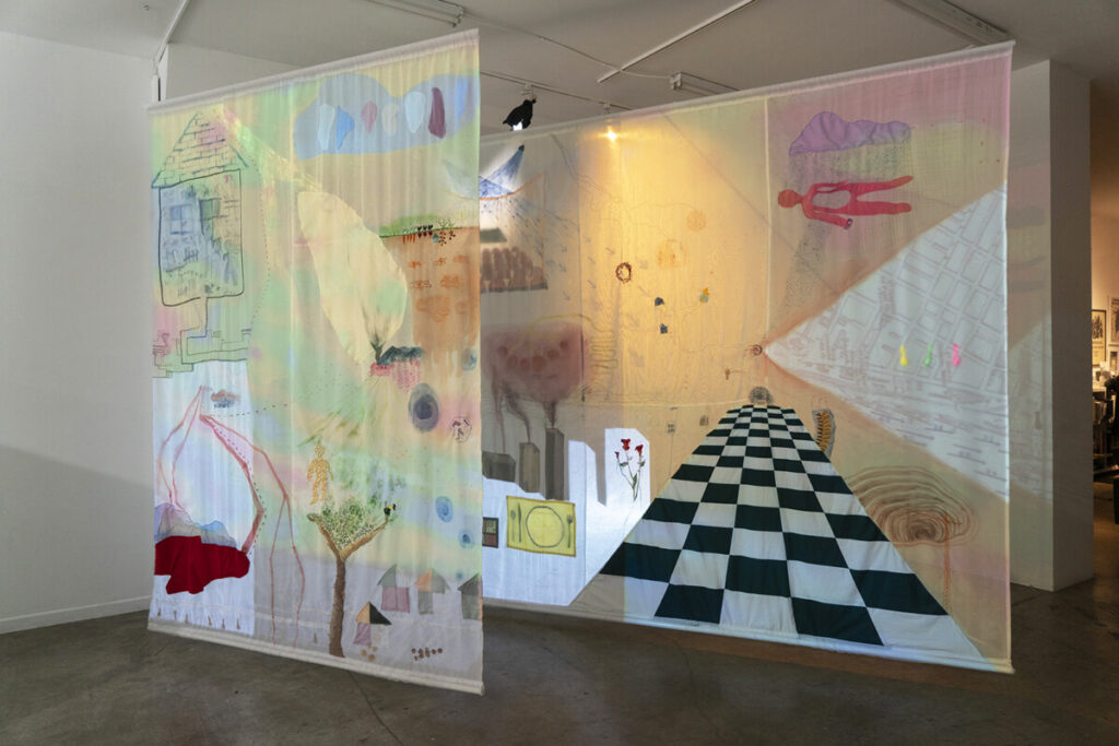
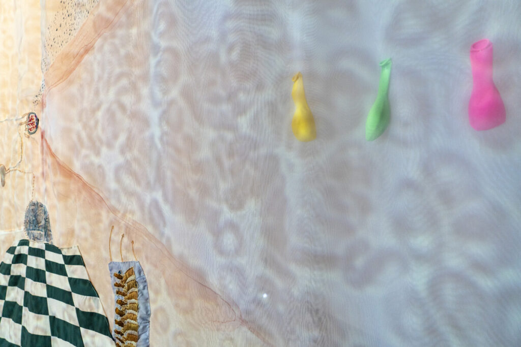
These pieces move with the breeze of people passing by and change according to the projections. Motifs of home take the form of place-settings with knives and forks, windows, checkered kitchen floors and flowers which are peppered through the tapestries, giving the exhibition a playful feel.

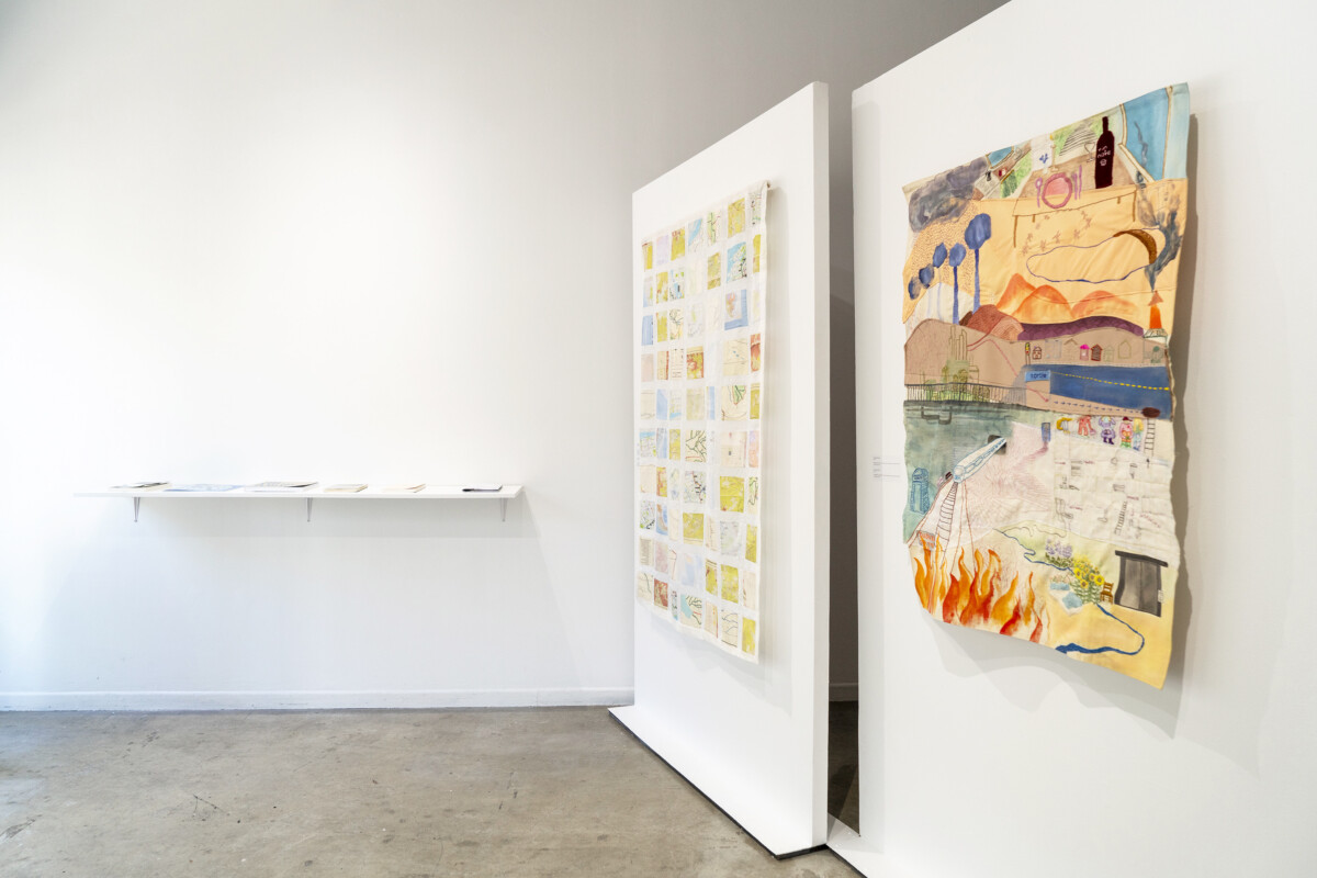
The exhibition as a whole is set up on a diagonal axis, further throwing the idea of a guiding map into question by tipping the axis of the North-South cardinal points. Greeting the viewers as they enter are two textile pieces, installed side by side on a diagonal wall. 

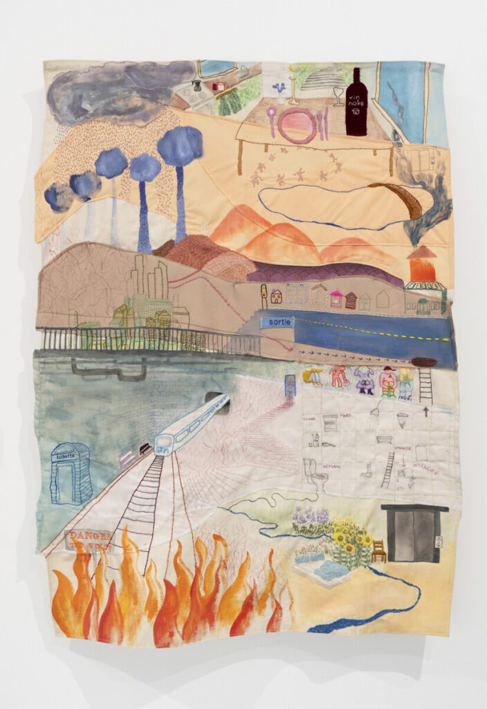
The first textile piece, “Autogéographies 1 (2021),” is one of the smaller ones in the show.  It is a quilt showing multiple scenes including a dinner table, a moving train, a garden, a fire, and finally hills receding into the distance, all in a colour palette of oranges, blues, and greys. 

Tania Lara, Autogéographies 1 (2021). Courtesy of La Centrale galerie Powerhouse. Photo by Lucie Rocher.

The second, “Autogéographies 2 (2021)” is another quilt in grid formation with each panel showing a different map, some with handwritten interventions on top. Together the two pieces set the tone for the show by playing with the idea of a map and rendering it soft in its materiality and personal in its content.

One of Lara’s noted influences in the project is Caribbean philosopher Édouard Glissant’s theorization of opacity as a response to colonial intervention. He questions the necessity for the transparency found in Western thought, and proposes opacity—the inability to see, the unknowable—as a method of self-determination, as though to say, you don’t need to know all of me to exist with me. 

Detail, Tania Lara’s Autogéographies. Courtesy of La Centrale galerie Powerhouse. Photo by Lucie Rocher.

Glissant writes in his seminal text Poetics of Relations, “opacities can coexist and converge, weaving fabrics.” Indeed, Lara weaves together opacities, allowing for moments of both transparency and obfuscation. Mapping is always an act of translation, from 2D to 3D, from the land beneath our feet to the pixels of the cell phones between our hands. Lara’s personal map is on display, and the key to its translation is just beyond our grasp. Perhaps it will always remain that way. 

“Autogéographies” is ongoing until Nov. 9, 2023 and is free to attend.

Categories
News

Launch of Montreal’s urban sprawl interactive map

 A Concordia student has developed a web-map to spread awareness of urban development in Montreal

Concordia undergraduate student Mirya Reid developed an interactive map of Montreal’s urban sprawl to raise awareness of the environmental impact of residential choices on future generations. The map was launched at an online panel on Oct. 1, leading into Campus Sustainability Month.

The is two webmaps side-by-side, the two maps convey different kinds of information, allowing the viewer to easily compare information in one map with the other and see how they are related. One map is of the urban sprawl in Montreal, the other map contains survey data on Concordia students resident preferences and perceptions of urban sprawl.

“Each map has a menu that allows people to select which variables they want to compare,” said Reid. “So you could choose to look at median income by borough in 2011 alongside levels of urban sprawl in 2011 and get a really clear visual of what that relationship looks like.”

The Montreal Metropolitan Community (CMM) released a report in 2020 that stated urban sprawl is intensifying across the outskirts of Montreal, and that the number of people driving from the suburbs to urban areas has increased steadily over the last decade.

The report goes on to say that the rise in single-family homes being built in the outskirts of urban areas is resulting in a loss of agricultural land and green space.

“It is increasingly apparent that urban sprawl is really not a sustainable form of urban development,” said Reid at the panel. She explained that there are significant greenhouse gas emissions associated with heating and cooling larger single-family detached homes in the suburbs.

According to Reid, the homes are built in areas that were created to be easier to get around by car rather than public transit. This contributes to greenhouse gas emissions, as well as the production of particulate matter which are linked to various respiratory illnesses.

“Sprawling development also results in ecological fragmentation which threatens biodiversity and the ability of natural areas to adapt to the increasing urban areas,” said Reid.

“The other reason we’re concerned about all this is because urban sprawl is increasing in Montreal, at alarming rates, and it’s been accelerating continuously since 1951. It has increased by 26 per cent between 1971 and 2011.”

Reid explained that there is a correlation between having more children and living in the suburbs, as having children generally demands more room. Yet she stated that it also depends on affordability: property is significantly more expensive downtown, thus some families must opt for the suburbs where it can be more affordable, while higher-income families are able to afford to live downtown.

“Some studies are finding that preferences can change with the younger generation,” said Reid. “My generation and millennials are increasingly choosing to remain in denser urban environments.”

According to a recent Statistics Canada report, Montreal and Toronto have had a record amount of people move from urban areas to the suburbs, as well as smaller towns and rural areas. The report states that Montreal had 24,800 people move from the city, while places like Farnham and Saint-Hippolyte had their population rise.

Reid explains that she learned how to create the interactive map in a class about geospatial technologies, where they were taught the programming language Python.

“It was stressful at times because I’m really not a programmer,” said Reid, who explained that she had only taken a few programming classes, and taught herself the rest with help from friends and the internet. “Sometimes I would start trying to do something without even knowing if it was actually possible, and just problem-solve until I ended up with what I like to call a ‘Franken-code’ that did what I wanted.”

“Doing that all summer was extremely fun and rewarding, it feels like a victory when you finally fix a bug or get something to work,” said Reid.

She received $4,620 of funding from the Sustainability Action Fund (SAF), which is a fee-levy group that gives the majority of its funding to support projects that develop sustainable infrastructure.

When asked why students should be interested in the interactive map, Reid explained that public trends should always be a priority for students. She stated that it is important for people to have a wide range of information on sustainability issues, including this one.


Photograph by Hadassah Alencar

Categories
Arts

Epigram(me): Putting yourself on the map

Concordia artist bends space by using old maps as a medium

Trusting in her artistic instinct, when Audrey “Em” Meubus came across a collection of Montreal maps from the 1980s, she knew she had to do something with them.

“I’ve always liked maps for what they represent—it’s finding yourself, and it’s the comforting feelings they evoke,” she said.

This discovery was the beginning of a project culminating in Epigram(me), Meubus’ first solo exhibition as an illustrator.

Meubus, who completed her BFA in film animation at Concordia in 2013, has worked on stop-motion animation sets for works such as The Little Prince. For her latest project, Meubus drew upon her skills as a writer, illustrator and animator to superimpose her striking, emblematic drawings on carefully-selected and significant sections of the city maps.

These works drew strong positive responses from Meubus’ friends and family.

“I would have groups of people forming around these maps, and I knew I was onto something… people were connecting [with them],” she said.

The strength of Meubus’ work comes from their symbolic meaning. Viewing an illustration superimposed over a map of a familiar area can generate strong personal responses connected to memory and belonging. The dark, graphic lines of Meubus’ illustrations contrast starkly with the sun-faded maps, making for an interesting aesthetic and contrast, engaging both the mind and emotions.

After having experimented with maps as a medium, the next step was teaming up with Studio Beluga, a Montreal-based non-profit organization run by a collective of artists, art professionals and curators. According to their website, the studio was established with the goal of facilitating artistic practices and forming a creative community.

“I know a lot of musicians and people from the theatre world, and that’s how I first came upon Studio Beluga,” she said. “I approached them, time went by until they eventually told me they had a space and I jumped on it.”

The final ingredient in the realization of Meubus’ project was the imposition of a strict two-week time limit on her creative process, in which she created the six pieces that were part of her exhibition.

“I do my best work on a deadline. I have all these ideas and just have to get them out of my head as fast as possible,” she said. “If I hit a wall with one of them, I can just put it aside and work on another one. This speedy and concentrated method allows me to not get bored with what I’m doing.”

Although her backdrops and drawings have particular personal significance, Meubus said she wants the viewer to find their own personal meaning in her work—hence the addition of (me) to Epigram. The name highlights her desire to spark the memory and imagination of the viewer in their own unique and distinctive fashion. In this way, the audience can rediscover something of themselves in these works, between Meubus’ illustrations and the locations the maps portray.

The exhibition runs at Théâtre Sainte-Catherine until April 15.

Categories
Arts

You don’t know your city till you’ve put an alley on the map

Press photo

Have you ever realized you’ve gotten lost walking or biking around Montreal’s countless little streets? Did you then try to visualize yourself on the map? Perhaps you were successful. But have you truly found yourself on the map? Studio Beluga hopes you find the answer to this question during their latest exhibition, Progression.

Studio Beluga was founded in 2009 with the goal of advancing the creative practices of emerging artists. Initially, the studio invited young artists to do a four month residency, working on any art form or subject of their choosing and then converting the studio into a gallery space to showcase their final products. Alina Maizel, a Concordia alumna, is one of the founders and directors of the studio. “It exists as a collective of people who love art, both artists and art amateurs, and we all just work together,” she said. Previously, Studio Beluga had locations in St. Henri and Mile End, but recently she, along with the other founders, many of whom are also Concordia alumni, wanted the studio to no longer have a physical location, focusing instead on pop-up events. “Instead of being restricted by the physical venue, [we felt that] we could really challenge people’s conventional idea of what an art gallery is by bringing them to outside spaces and saying: this is an art gallery,” Maizel explained.

The theme of the exhibition is the urban environment and it will be an attempt at mapping it, using cartography and conceptually examining what a map means. “Curatorially, it would be most fascinating to take that concept all the way through and have the exhibit outside on the streets. Further even, instead of having it on the streets, which is what a map usually outlines, we decided to put it in the inverse of what a map outlines, which is the alley, the part of the city that is not mapped,” Maizel said.

Exhibiting his work in the alley is Montreal artist and poet Cam Novak. A year ago, Novak was running a courier service which put him in close connection with the city of Montreal’s map, an essential tool for dispatching and delivery. “I had a map of Montreal over my desk that I would use to help dispatch my couriers … it was this weird ‘I hate you but I love you’. So I took it down off my wall and drew on it and it was like a fuck you to the map,” said Novak, adding “you [the map] were dictating what you wanted to me, my whole career, and now I am dictating you… it felt right.”

While Novak’s relationship to the Montreal map is still turbulent, the year spent preparing for the Progression exhibit has introduced a new fascination with issues of identity, particularly his own.This evolution of his art was the inspiration behind a five-foot high installation of a giant head with parts of the map embedded in it, which he has prepared for the exhibit.

“Instead of saying fuck you to the city, I am acknowledging that it has been an intrinsic part of who I am as an individual, and it has built who I am. And hence, progression,” Novak explained.

Along with Novak, Montreal-based FredC and French artist Joanathan Bessaci will be showcasing their work at the exhibition that will be held in the garden behind 16 St. Viateur West, the alleyway entrance.

Progression will take place for one day only on Sept. 7, from 5 p.m. until 10 p.m. Admission is free.


Exit mobile version